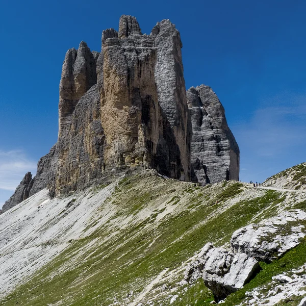
Tre Cime di Lavaredo Loop
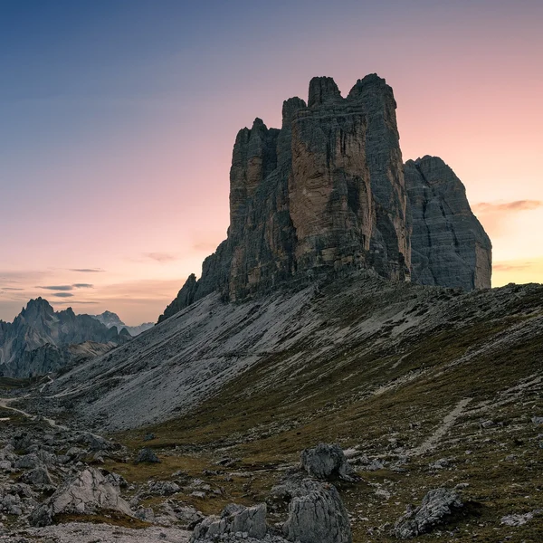
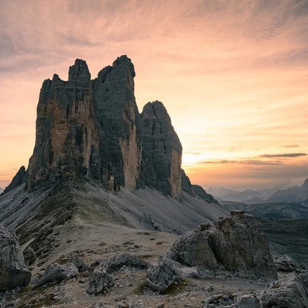
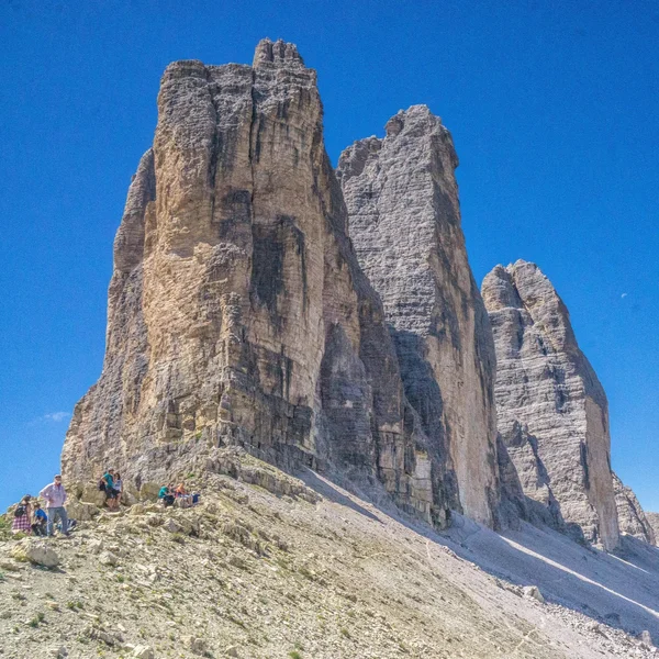
★★★★★ 4.7/5 · 400+ Verified ReviewsThe Tre Cime di Lavaredo Loop is the definitive day hike of the Dolomites, circling the iconic limestone monoliths that serve as the symbol of the region. This circuit covers approximately 10 km6.2 mi, offering constantly shifting perspectives of the Cima Piccola, Cima Grande, and Cima Ovest. Hikers traverse high-altitude gravel paths, World War I remnants, and alpine lakes, all while maintaining an average elevation above 2,200 m7,218 ft.
Table of Contents
Map of the Tre Cime di Lavaredo loop
The Tre Cime di Lavaredo (Drei Zinnen) act as the majestic boundary stone between the Italian provinces of Belluno (Veneto) and South Tyrol. Geologically, they are the crown jewel of the Sesto Dolomites nature park. The trail map below highlights the classic "Giro delle Tre Cime" (Tour of the Three Peaks), a loop that encircles the monoliths.
While the arrows on standard maps indicate a counter-clockwise route (Auronzo to Locatelli), consider hiking clockwise if visiting during peak season. This strategy allows you to move against the flow of the main crowds and often provides superior lighting for photography in the afternoon.
Which Route Option is Best for You?
The Tre Cime di Lavaredo can be experienced in two ways: the commitment of the full circuit or the accessibility of the saddle. Both offer world-class views, but they serve different fitness levels.
Option #1: The Classic Loop
- Who is it for? Active hikers comfortable with 4+ hours of movement.
- The Reality: Many guides label this "easy." It is not. While technically simple (no scrambling), the 10 km6.2 mi circuit involves significant ups and downs, particularly the steep climb out of the Rienzboden valley after Rifugio Locatelli. Treat it as a proper mountain day, not a park walk.
- Time: Allow 4 to 5 hours to enjoy the scenery without rushing.
- Pro Tip (Crowd Control): Most visitors hike counter-clockwise (Auronzo -> Lavaredo -> Locatelli). If you see a wall of people on Trail 101, flip the script. Hiking clockwise (taking Trail 105 first) puts you against the flow, offering solitude on the western side and better lighting for the north faces in the afternoon.
Option #2: The Saddle Viewpoint (The "Lite" Version)
- Who is it for? Families with small children, seniors, or those with limited time (2-3 hours).
- The Route: Hike from Rifugio Auronzo to Forcella Lavaredo (The Saddle) and back.
- Why do it? You still get the "money shot." The saddle is where the dramatic north faces are first revealed. You miss the lakes and the wester scenery, but you see the icons without the grueling ascent of the full loop.
Forcella Lavaredo
Can You Find Solitude?
Even on busy days, silence can be found just meters off the main track.
The "Angel of the Fallen": Near the trailhead chapel, a small path branches right into a boulder field. Here stands a moving statue by sharpshooter Ancona Vittorio Monelli, honoring the WWI dead away from the selfie crowds.
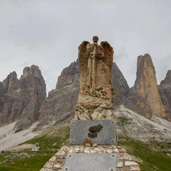
The Angel of the Fallen statue near Rifugio Auronzo in the Dolomites for the Tre Cime di Lavaredo Loop The Pope’s Plaque: At Forcella Lavaredo, instead of rushing to the hut, walk toward the base of Cima Piccola. A plaque on a boulder commemorates Pope John Paul II’s 1996 visit, inscribed with his famous words: "Do not be afraid."
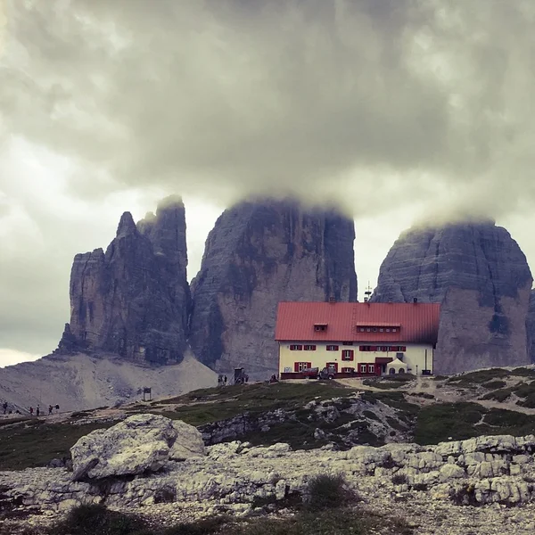
The "Secret" Plateau: Most hikers crowd the terrace of Rifugio Locatelli. For a private lunch spot, walk just past the hut to the small Chapel of San Bernardo (patron saint of mountaineers). The plateau just north of here offers the same iconic view of the peaks but with zero noise.
When Should You Go & How to Check Conditions?
The Best Season & Time of Day
The hiking window is dictated by the snow line and the opening dates of the mountain huts.
- The Season: The prime window runs from late June to mid-October.
- July/August: The wildflowers are at their peak, but so are the crowds. Thunderstorms are common in the afternoons.
- September/October: This is the "Golden Season." The air is crisp, the larch trees turn yellow, and the stable high-pressure systems often provide the clearest views. However, be prepared for freezing temperatures in the morning.
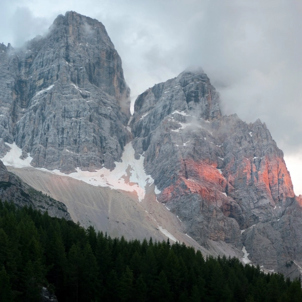
- The Lighting Strategy: While the parking reservation system may dictate your arrival time, photographers should note the sun's position. In the morning, the iconic North Faces are backlit, creating silhouettes. The sun only hits the faces of the Three Peaks in the late afternoon/evening, turning them red (Enrosadira) at sunset.
Tre Cime di Lavaredo (Dreizinnen), Sesto dolomites, from the east
How to Check the Weather (The Right Way)
Alpine weather is notorious for fooling generic phone apps (like Apple Weather), which often pull data from warm valley towns and fail to account for the conditions at 2,400 m7,874 ft.
- The Gold Standard: We rely exclusively on Meteoblue. It is the only model that accurately predicts mountain microclimates, specifically the "cloud cover" density at different altitudes.
- Live Forecast: You don't need to hunt for data. We provide a real-time 7-day forecast powered by Meteoblue directly on this page. Check the widget below to see wind chill, precipitation probability, and cloud ceiling before you drive up.
Accessing the Real-Time Webcams
Conditions at Rifugio Auronzo can be radically different from the valley floor in Cortina. Before driving up, check the live cams to avoid staring into a white wall of fog.
Rifugio Locatelli Cam: The most famous view, looking back at the peaks from the north.
How Do You Reach the Trailhead?
The Tre Cime di Lavaredo tower over the border of South Tyrol and Belluno (Veneto), situated within the Drei Zinnen Nature Park. The closest logistical bases are Dobbiaco (Toblach) to the north and Cortina d’Ampezzo to the south. The primary trailhead is Rifugio Auronzo, accessible via the scenic Strada Panoramica.
Reaching Tre Cime by Foot (The Hiker's Entry)
If the toll road is full or you wish to save the fee, you can "earn the view" by hiking up.
- Option 1 (Standard): Start at Lago d’Antorno (just before the toll gate). Follow Trail No. 101.
- Stats: 4.3 km2.7 mi distance with 506 m1,660 ft elevation gain.
- Time: Allow roughly 1.5 to 2 hours one-way.
- Option 2 (Expert): Start from Val Fiscalina in the north. This is a significantly longer, steeper approach via Trail 102/103 that leads to Rifugio Locatelli first. This is recommended only for fit parties seeking a full-day sporting challenge.
Reaching Tre Cime by Bus (Public Transport)
Using the shuttle system is highly recommended to avoid the parking stress. However, the system differs depending on your starting point.
From Dobbiaco / Toblach (The North):
- Line: Shuttle 444 (Dobbiaco Station → Lago di Landro → Rifugio Auronzo).
- Tickets: Booking online via the südtirolmobil website or app is mandatory in high season. Walk-up seats are virtually non-existent in July and August.
- Warning: The standard Südtirol Guest Card (museum/transport pass) is NOT valid on this line. You must purchase a specific ticket.
From Cortina d’Ampezzo (The South):
- Line: DolomitiBus (typically Line 30/31 or 50/51) connects Cortina to Misurina Genzianella. From there, you must transfer to the shuttle bus up to the Rifugio.
- Tickets: Check schedules and fares on the DolomitiBus app.
- Payment: While apps are preferred, if buying on board, bring cash and coins. Many buses on the southern side still struggle with card processing in dead zones.
How to Get There by Car (The Toll Road)
Driving offers the most flexibility but requires navigating the strict quota system. From Lake Misurina, drivers turn onto the private toll road that leads up to the refuge.
Season Dates: For 2026, the road is tentatively scheduled to open in late May and close in late October. These dates are dictated entirely by snow clearance; a late spring blizzard can delay opening by weeks.
Real-Time Status: Never assume the road is open in shoulder season. Always check the official local tourism websites before driving up.
Rental Tip: If renting a car, ensure you book the parking slot before you have your license plate (update it later) to secure your entry.
How Does the Mandatory Parking System Work?
How to Reserve Parking for Tre Cime di Lavaredo in 2026
For the 2026 season, the "drive up and pay" model has been abolished during peak hours (07:00 to 17:00). Access for private vehicles is controlled by a mandatory online reservation system managed by the Municipality of Auronzo.
Slots must be secured via the official portal https://auronzo.info/en/parking-tre-cime-di-lavaredo/ or its designated booking engine. The system generally opens for reservations in late May, operating on a rolling basis roughly 30 days before the travel date.
How to Book a Parking Permit
The booking process allows for the selection of a specific date and entry time slot (starting from 07:00). During checkout, the following data is required: email, phone number, and the vehicle license plate number. Payment is collected immediately via credit card.
Crucially, same-day reservations are not permitted. All bookings must be finalized no later than 11:59 PM on the day prior to the visit. The license plate serves as the digital permit; no physical ticket is generated.
Tre Cime Parking and Toll Fees for 2026
The pricing structure for the toll road and parking is as follows:
- Cars: €40.00
- Motorcycles: €26.00
- Campervans/Motorhomes: €60.00
- Buses (up to 30 seats): €80.00
- Buses (over 30 seats): €160.00
- Disabled Visitors: Free (requires prior registration).
When Do Reservations Open?
Tickets are released in batches approximately one month in advance. Availability fluctuates daily. During the peak window (July and August weekends), slots frequently sell out 3 to 5 days prior to the date. Immediate booking upon finalizing travel plans is strongly advised.
Are Cancellations or Reschedules Permitted?
Modifications are restricted. Direct rescheduling of a date is not possible; the user must cancel and rebook.
- Refunds: Cancellation is free and fully refundable up to 5 days before the scheduled visit.
- Non-Refundable Window: Within 5 days of the booking, no refunds are issued. Bad weather (rain, fog, or lack of visibility) is not accepted as a valid reason for a refund, necessitating a check of the long-range forecast before the 5-day cutoff.
Rules & Penalties
- Overstay: The fee covers a 12-hour period. Exceeding this window results in a double fee (e.g., an additional €40 for cars) charged at the exit barrier.
- Re-Entry: Exiting the toll road terminates the session. Re-entry is not permitted on the same ticket.
What if the License Plate is Unknown?
Travelers utilizing rental cars can secure a reservation without immediate plate details. The system permits the booking holder to log in and update the vehicle registration number up until 11:59 PM on the day before the visit. Failure to input the correct plate by this deadline will result in denied access at the automated barrier.
Is the Arrival Time Strictly Enforced?
The reserved time slot marks the start of the eligibility window, not a strict appointment. Vehicles may enter at the booked time or anytime thereafter, provided it falls within the operational hours. For example, a 07:00 booking allows for an arrival at 09:00 without penalty. However, the 12-hour clock begins upon entry.
What Essentials Must Be in Your Pack?
The Tre Cime loop maintains an average altitude of 2,300 m7,500 ft. At this elevation, the atmosphere provides 25% less UV protection, and the weather can shift from sun to hail in under 20 minutes. Do not let the "tourist" crowds fool you; this is a serious alpine environment that punishes poor preparation.
Footwear
- Boots vs. Approach Shoes: Standard running shoes are dangerous here. The trail consists of sharp, crushed dolostone (scree) which shreds soft mesh and offers zero traction on the steep descent into the Rienzboden valley.
- The Recommendation: You do not necessarily need heavy leather boots, but you must have footwear with a Vibram® (or equivalent) lugged sole and a reinforced rubber toe cap. "Approach shoes" (like La Sportiva or Salewa) are the local standard: they grip wet rock and protect toes from loose scree.
- Hiking Poles: These are critical for knee health on this specific loop. The descent from Rifugio Locatelli involves loose gravel on a hardpack base. Poles transfer weight and prevent slips on the "marbles" underfoot.
Sun & Skin Protection
- The "White Oven" Effect: The pale limestone of the Dolomites reflects up to 20% of UV radiation, effectively doubling your exposure. Even on cloudy days, the risk of sunburn is extreme.
- Eye Protection: Sunglasses are mandatory. Ensure they are Category 3 or 4 to prevent eye fatigue from the glare.
- Sunscreen: Apply a sweat-resistant SPF 50+ before you leave the car. The dry mountain air evaporates sweat instantly, making you feel cooler than you actually are while you burn.
Clothing Strategy
- The Wind Tunnel: The Forcella Lavaredo saddle acts as a natural funnel for northern winds. It is often 10°C colder here than at the parking lot.
- The Layering System: Avoid cotton (it freezes when wet). Wear a synthetic or merino wool base layer. Pack a fleece mid-layer and a hard-shell windbreaker. If hiking in June or October, a beanie and lightweight gloves are non-negotiable.
Tech & Safety
- Power Management: Cold temperatures and constant camera usage drain phone batteries rapidly. Carry a power bank (10,000mAh) and a cable. You will need your phone for the return shuttle ticket or emergency calls.
- Offline Navigation: Cell signal drops completely in the shadow of Monte Paterno. Download the map area on Google Maps, Komoot, or Fatmap before leaving the hotel.
Nutrition & Logistics
- Hydration: The dry air accelerates dehydration. Carry 2 l67 fl oz of water. Consider adding electrolyte tablets to prevent altitude headaches.
- Cash is King: While huts have card terminals, they rely on satellite connections that frequently fail during storms or peak usage. Always carry ~€50 in mixed cash (small bills and €1 coins for toilets) to ensure you can buy food and use facilities.
Where Can You Stay & What's Nearby?
Strategic Base Camps
The Tre Cime are located in a "dead zone" for major cities (Bolzano is 2+ hours away). To beat the crowds, you should base yourself in one of the nearby valley towns:
- Dobbiaco (Toblach) & San Candido (Innichen): The best options for families. These towns are 30-40 minutes north of the peaks and offer direct access to the shuttle bus system, plus excellent hotels and wellness centers.
- Cortina d’Ampezzo: The "Queen of the Dolomites" to the south. It offers high-end luxury and dining but comes with higher prices and heavier traffic.
- Misurina: The closest option, sitting right at the base of the toll road. Accommodation here is more dated but unbeatable for location.
Staying Overnight in the Mountains (Rifugios)
Sleeping at altitude allows you to witness the sunrise before the day-trippers arrive.
- Rifugio Auronzo: Accessible by car. It feels more like a hotel than a hut.
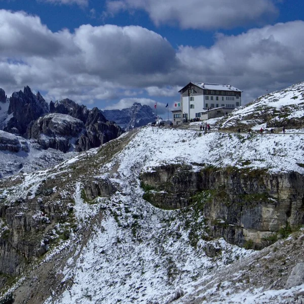
Auronzo Hut in the Dolomites - Rifugio Lavaredo: A 20-minute walk from the parking. Smaller and quieter.
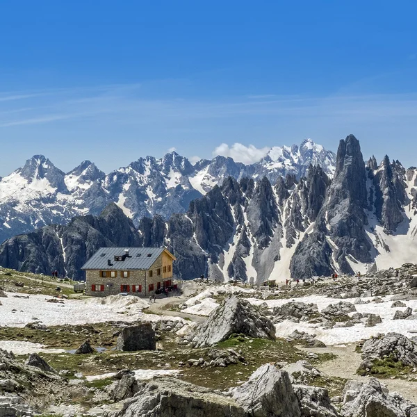
Lavaredo Hut in the Dolomites - Rifugio Locatelli (Dreizinnenhütte): The most famous location, facing the north faces.
Locatelli Hut in the Dolomites - Booking Reality: These huts are open from late June to late September. They do not use booking platforms. You must email them directly, often 6 to 8 months in advance for high-season dates.
Camping & Campervans
- Wild Camping: Strictly forbidden within the Drei Zinnen Nature Park. Rangers patrol frequent spots, and fines are heavy. Do not pitch a tent near the lakes.
- Campervans at Rifugio Auronzo: The parking lot allows overnight stays for campervans (Category B ticket: €60). Note: This is a parking lot, not a campsite. There are no electrical hookups or water services. You are paying for the privilege of waking up at the trailhead.
- Official Campsites: For full services, use Camping Toblacher See (near Dobbiaco) or Camping Caravan Park Sexten, both top-tier facilities with bus connections to the peaks.
Is This More Than Just a Hike?
The Tre Cime di Lavaredo are a UNESCO World Heritage site, but they are also a former battlefield. Hiking here is a journey through the "White War" (1915–1918), where the Italian Alpini and Austrian Kaiserjäger fought on the "rooftops of the world."
The "White Death"
The frontline cut directly through these peaks. While bullets were a threat, the mountains themselves were the true executioner. Soldiers on both sides faced the "White Death" avalanches and subzero blizzards. In December 1916 alone, a single series of avalanches buried over 10,000 troops across the Dolomites.
As you hike near Monte Paterno (Paternkofel), look up at the rock face. The rectangular "windows" carved into the cliffs are gun emplacements and observation tunnels, still accessible today for those with helmets and headlamps.
A Tale of Two Names
You will see the peaks referred to as both Tre Cime (Italian) and Drei Zinnen (German). This is not just a translation; it is a geopolitical relic. Before 1918, this ridge was the border between the Kingdom of Italy and the Austro-Hungarian Empire. Following the armistice, South Tyrol was ceded to Italy, but the German name, meaning "Three Merlons" (like the battlements of a castle) remains the primary identifier for the local Tyrolean population.
Explore More Treks
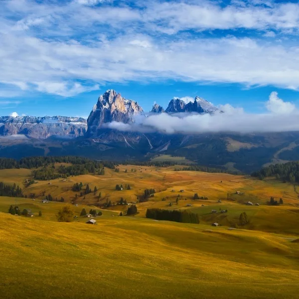
Alpe di Siusi
Experience Europe's largest high-altitude alpine meadow. The Panorama Traverse offers a gentle yet spectacular circuit through emerald pastures, framed by the anvil-shaped Sciliar and the towering spires of the Sassolungo. Perfect for photographers and families alike.
Alta Via 1
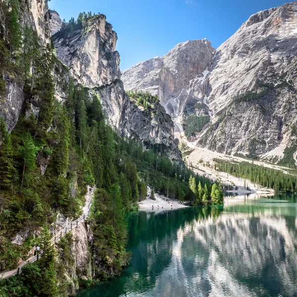
The definitive multi-day journey across the heart of the Dolomites. Spanning 120km of rugged limestone terrain, this classic trek takes you from the emerald waters of Lago di Braies to the historic streets of Belluno, staying in world-class mountain huts along the way.
Cinque Torri Loop & WWI Open Air Museum
Explore one of the most famous rock formations in the Dolomites. This guide covers the WWI trenches, the loop around the five towers, and the climb to the historic Rifugio Nuvolau.
Lago di Braies
Visit the most famous lake in the Italian Dolomites. This guide covers the essential shoreline loop, the easy hike to Malga Foresta, and critical 2026 parking and shuttle regulations.
From our partner · 400+ Verified Traveler Reviews
"This trek is magnificent. The itinerary is perfect, and our guide was extraordinary - knowledgeable, attentive, and genuinely passionate about the Dolomites."
"Well-marked trails that avoid the crowded tourist spots, with real elevation changes that keep it interesting. The mountain hut stays were a highlight - the Italian food at every rifugio was outstanding."
"Our guide was super professional. The transportation was seamless, and the family-run hotel was very comfortable - a friendly and safe setting. I would do it again in a minute."
"Excellent itinerary, excellent guide. Every detail was handled perfectly and the route choices were spot on. Would do it again without hesitation."
"A spectacular trek through an exceptional mountain range. The route avoids the most crowded areas and the views are relentless. Be warned - the elevation changes are more demanding than you expect."
"A genuinely engaging trek that keeps you motivated day after day. The variety of landscapes - from green valleys to high rocky passes - is remarkable. Well organized from start to finish."
"I rate this trip 10 out of 10. The accommodation quality exceeded my expectations, and the staff were incredibly attentive - even accommodating my food allergies without any fuss."
"An extraordinary itinerary that lets you discover the Dolomites without overexerting yourself. The route is well-balanced with no technical difficulties, yet you still feel immersed in the high mountains."
"A great discovery for a first group hiking trip. The guide was excellent, the group was friendly, and the autumn weather gave us clear skies over the Dolomites nearly every day."
"A wonderful week in the mountains with an excellent guide who knew every trail and every shortcut. The hut-to-hut format made the logistics effortless - just walk and enjoy."
Decades of Alpine Expertise
Our partner agency has been operating in the Alps for over 40 years. Their team of passionate mountain experts knows every trail, every rifugio, and every season intimately.
Fully Protected Trips
Your investment is safe. We work exclusively with a licensed, bonded, and insured operator. 24/7 assistance and comprehensive travel insurance are included with every booking.
Handcrafted by Locals
No generic packages. Each itinerary is designed by a small team of travel experts who hike these trails themselves. Luggage transfers, dietary needs, and every logistical detail are handled for you.
A Real Team, Not a Call Center
A dedicated team of a dozen specialists is available before, during, and after your trip. You speak directly to the people who designed your route and know the terrain.