Alta Via 1
★★★★★ 4.7/5 · 400+ Verified ReviewsThe Alta Via 1 is a renowned long distance trail traversing the Italian Dolomites for 120 km74.6 mi from Lago di Braies to Belluno. This high path reaches a maximum altitude of 2,752 m9,029 ft at Rifugio Lagazuoi. The total elevation gain across the itinerary is roughly 6,665 m21,867 ft. Hikers usually complete this journey over 9 days, navigating through spectacular alpine landscapes and historic mountain terrain.
Table of Contents
Daily Itinerary
Lago di Braies to Rifugio Sennes
Expert Logistics: During peak summer, the road to Lago di Braies is closed to private vehicles from 09:30 to 16:00. You must book the public shuttle bus from Dobbiaco/Villabassa well in advance to reach the trailhead.
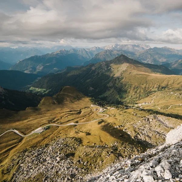
The journey commences at the shores of Lago di Braies, situated at an altitude of 1,496 m4,908 ft. This initial section follows the eastern bank of the lake before transitioning into a rigorous ascent toward the heart of the Braies Dolomites. The trail climbs steadily through thickets of mountain pine, eventually entering the rugged and stony terrain of the Nabige Loch.
A final, demanding stretch over steep scree slopes leads to the Forcella Sora Forno pass at 2,388 m7,835 ft. At this vantage point, the scenery shifts dramatically from the lush valley below to the stark, expansive limestone plateau of Fanes-Sennes-Prags. An optional detour from the pass allows for a one-hour climb to the summit of Croda del Becco, reaching 2,810 m9,219 ft and offering panoramic views of the surrounding peaks. The stage concludes with a straightforward descent across the high alpine pastures to reach Rifugio Sennes at 2,126 m6,975 ft
Rifugio Sennes – Rifugio Fanes / Lavarella
The V-Shaped Profile: This stage explores a region defined by sharp geological transitions, characterized by a massive drop and immediate climb.
The day opens on the broad, undulating pastures of the Sennes plateau, where the trail meanders toward the southern rim of this high-altitude basin. Here, the geography shifts abruptly as the path begins a plummeting descent into the Val de Mareo. Hikers navigate a historic military road, comprised of tightly woven switchbacks that carve a steep passage down the mountainside. This rigorous section drops nearly 600 m1,969 ft before leveling out at Rifugio Pederü, a strategic stop located on the valley floor at 1,548 m5,079 ft.
Leaving the valley behind, the trail immediately commences a steady climb back into the high country. The route weaves through thick forests of mountain pine and larch, offering cool, shaded paths before the trees give way to the stark beauty of the higher elevations. This upper reach is dominated by the Karst limestone formations that make the region famous. The rock here is fractured and weathered into a lunar-like pavement, creating a fractured grey landscape that stands in sharp relief against the surrounding summits.
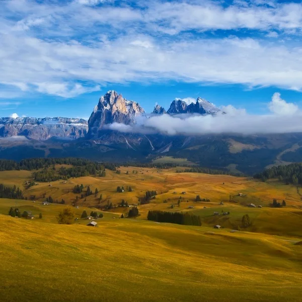
The ascent eventually yields to the lush, rolling greenery of the Fanes plateau, a place deeply embedded in local Ladin mythology. Often described as a grand natural amphitheater, the plateau is traversed via the Vara valley, leading toward the day's conclusion. The path terminates at either the historic Rifugio Fanes at 2,060 m6,759 ft or the neighboring Rifugio Lavarella at 2,042 m6,699 ft. These refuges are nestled within a sheltered basin, flanked by the massive limestone walls of the Croda del Vallon Bianco and the Cime di Fanes. The stage ends in this tranquil high-altitude sanctuary, where the silence is broken only by the calls of local marmot colonies.
Rifugio Fanes / Lavarella – Rifugio Lagazuoi
The Vertical Challenge: Prepare yourself physically for this stage. It features the most grueling vertical ascent of the northern route, testing your endurance over a massive 1,350 m4,429 ft climb.
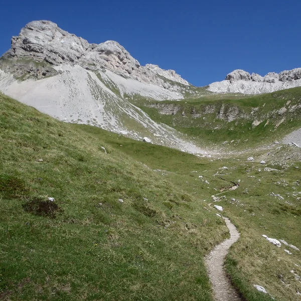
Rising from the tranquil meadows of the Fanes plateau, the route ventures into a landscape characterized by its raw, elemental beauty. The path climbs steadily toward the Passo Limo at 2,172 m7,126 ft, passing its namesake lake before opening into the Pian de Gran Fanes. This vast, high-altitude basin serves as a wilderness of rock and sparse vegetation, where the trail follows the contours of a rugged terrain that feels increasingly remote. A long, sustained descent follows, leading hikers down through the Val di Fanes toward the trailhead at Capanna Alpina, situated at 1,729 m5,673 ft.
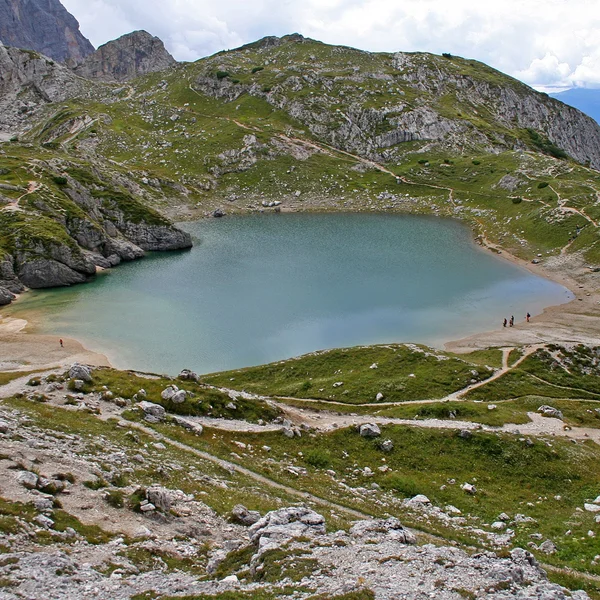
From the valley floor, the character of the day shifts toward a rigorous and steep ascent. The path climbs toward Rifugio Scotoni, a mountain hut nestled within a sheer-walled limestone amphitheater at 1,985 m6,512 ft. Beyond this point, the terrain becomes increasingly vertical as the trail scales the headwall to reach the Lago di Lagacio, a striking turquoise alpine lake hidden beneath the peaks. The water provides a brief moment of serenity before the final, grueling push. Hikers must navigate a relentless series of switchbacks across a steep scree slope to reach the Forcella Lagazuoi, a narrow mountain pass that serves as the gateway to the summit ridge.
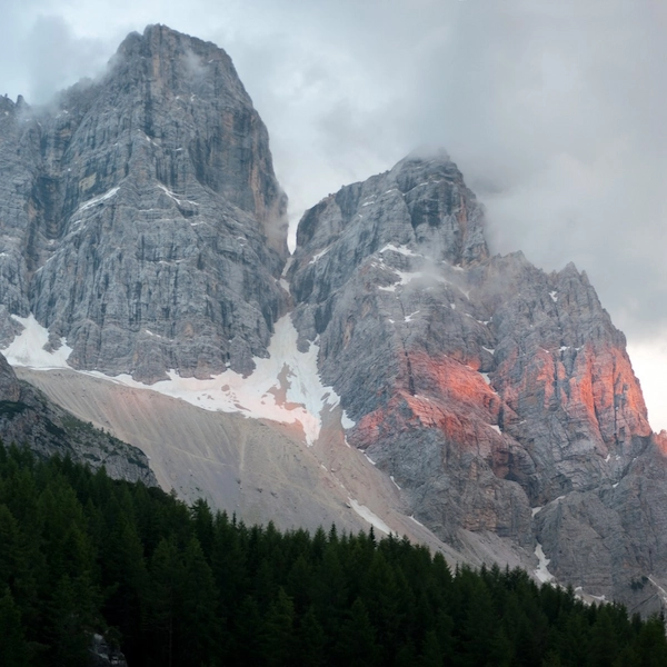
The stage culminates at Rifugio Lagazuoi, perched precariously at an elevation of 2,752 m9,029 ft. As one of the highest mountain huts in the region, it offers a 360-degree panorama that encompasses the Tofane, the Marmolada glacier, and the Sella Group. This location is celebrated for providing the most spectacular sunset views in the Dolomites and for its profound historical weight. The surrounding cliffs are honeycombed with tunnels and trenches from the First World War, turning the summit into an open-air museum where the stark beauty of the peaks meets the remnants of human history.
Rifugio Lagazuoi – Rifugio Nuvolau / Averau
Descending from the high-altitude stronghold of Lagazuoi, the route immediately enters a realm of deep historical significance. Historic Detour: Hikers may choose between a panoramic descent over open slopes or an immersive passage through the Galleria del Lagazuoi, a complex system of tunnels engineered during the Great War. This subterranean path requires a helmet and headlamp to navigate the steep, narrow galleries that once sheltered soldiers within the mountain's heart.
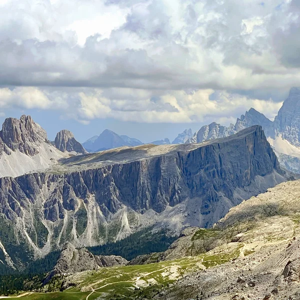
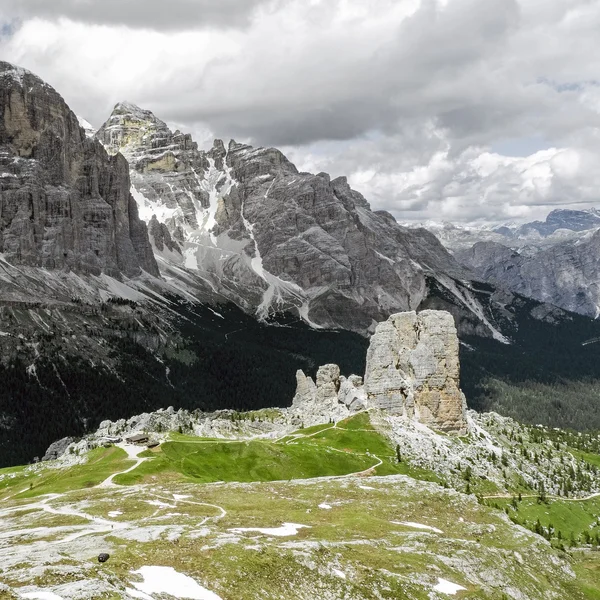
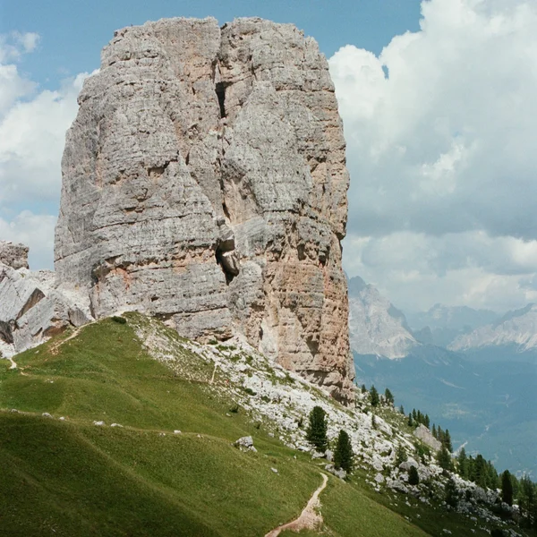
Upon reaching Passo Falzarego at 2,105 m6,906 ft, the trail crosses the mountain pass and transitions into soft alpine meadows, beginning a steady climb toward the distinct geological formations of the Cinque Torri. The path weaves directly between these five limestone towers, providing an intimate perspective of the vertical rock faces and the nearby open-air war museum. This area showcases a stark contrast between the natural beauty of the stone and the remnants of military history.
The ascent continues toward the Forcella Nuvolau, passing Rifugio Averau at 2,413 m7,917 ft, which sits nestled between the peaks of Averau and Nuvolau. This high-altitude refuge serves as a brief pause before the final climb of the day. The stage culminates with a trek along a narrow, rocky ridge to reach Rifugio Nuvolau at 2,575 m8,448 ft. Originally built in 1883, this historic hut is famously perched on the edge of a vertical precipice, resembling an eagle's nest. From this unparalleled vantage point, the horizon is dominated by the Marmolada, the Sella Group, and the Tofana di Rozes, offering one of the most expansive and iconic panoramas in the entire Dolomites region.
Rifugio Nuvolau / Averau – Rifugio Passo Staulanza
Knee Protection Warning: Prepare for a massive 1,200 m3,937 ft of descent today.
Departing from the narrow, windswept ridge of Nuvolau, the route immediately tackles a steep and rugged descent toward the valley below. This initial section includes a series of steps and fixed cables to assist hikers through the more precipitous rock faces, although a less demanding bypass is available for those preferring a steady walk down to Passo Giau. At 2,236 m7,336 ft, this prominent mountain pass marks a temporary return to civilization before the trail strikes out into the isolated wilderness surrounding the colossal Monte Pelmo. The transition from the bustling road pass to the silent, rocky slopes of the massif is swift and dramatic.
The path continues by contouring along the base of this limestone giant, weaving through the Città di Sassi, a remarkable field of boulders that creates a natural stone labyrinth across the mountainside. As the journey progresses toward the Forcella Ambrizzola at 2,277 m7,470 ft, the starkness of the high peaks begins to fade, replaced by the softening features of the alpine landscape. From the pass, the vista opens to reveal the rolling green pastures and deep valleys that characterize the southern approaches to the Pelmo group, offering a sense of scale and serenity.
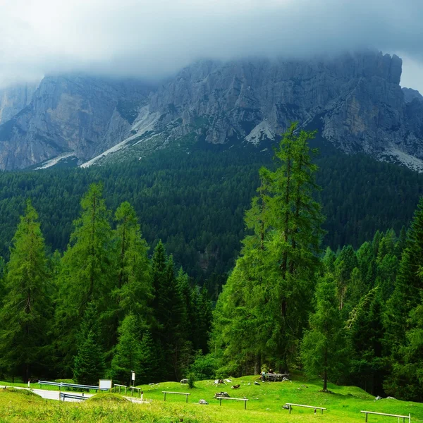
The final descent leads away from the high scree and into the cooling shelter of ancient larch forests. The trail meanders through these fragrant woodlands and open meadows, descending steadily until it reaches the mountain pass at Passo Staulanza. The day concludes at Rifugio Passo Staulanza, a welcoming outpost located at 1,766 m5,794 ft. Situated in the saddle between the shadows of Monte Pelmo and the distant towers of the Civetta, the refuge offers a tranquil setting amidst the trees, providing a perfect contrast to the jagged heights navigated earlier in the day.
Passo Staulanza - Rifugio Vazzoler
Navigating the southern reaches of the Civetta massif, the trail transitions from the towering verticality of the central peaks toward the rugged complexity of the Moiazza group. The path winds through a series of jagged towers and deep gullies, characterized by an undulating course that demands constant attention. This section leads across the Masks of Moiazza, where vast fields of scree and shattered rock accumulate directly beneath the looming limestone cliffs. While the horizontal distance covered is relatively short, the technical nature of the uneven footing ensures a steady and engaging pace through this primitive environment.
The terrain eventually yields as the trail descends toward Passo Duran, situated at 1,601 m5,253 ft. This mountain pass serves as a primary link between the Val di Zoldo and the Agordino region, acting as a convenient exit point for those on a more condensed schedule. Beyond the pass, the route maintains its elevation to reach Rifugio Carestiato, which sits at 1,834 m6,017 ft on the Col dei Pass. The refuge is located in a prime position at the base of the massive Moiazza Sud walls, providing a striking contrast between the vertical rock and the softening green slopes below.
The stage concludes with an expansive view toward the south, where the horizon is defined by the wild and jagged silhouettes of the Dolomiti Bellunesi. This transition marks a shift in the landscape, as the massive, isolated blocks of the central Dolomites give way to the more fractured and less-traveled ranges of the southern frontier. The refuge offers a peaceful vantage point to observe the changing light on the surrounding peaks, serving as a tranquil resting place before the final segments of the journey.
Rifugio Vazzoler - Passo Duran
Crossing into the Dolomiti Bellunesi National Park marks a definitive transition into a landscape that feels significantly wilder, greener, and more solitary than the northern reaches of the route. The journey begins with an extensive traverse around the southern flanks of the Moiazza, where the trail navigates through a rugged environment of weathered rock and expanding alpine flora. This path leads toward the base of the Cime de Zita, where the terrain shifts abruptly into a rigorous and technically demanding ascent. The trail climbs steeply toward the Forcella de Zita Sud at 2,395 m7,858 ft, providing a high-mountain experience characterized by narrow, exposed sections of ridge walking. With precipitous drops on either side, this passage offers dramatic, unobstructed vistas of the surrounding wilderness and the deep, silent valleys below.
Upon cresting the ridge, the character of the trek shifts as the path plunges down a very steep, grassy incline into the heart of a spectacular glacial cirque. This natural amphitheater, known as the Van de Zita, is a place of profound stillness and natural beauty, where the sheer scale of the surrounding peaks creates a sense of total isolation. The descent continues through these ancient glacial features, following the natural contours of the basin before the terrain begins to level out. The day concludes at the remote and charming Rifugio Pian de Fontana, situated at 1,632 m5,354 ft. Perched amidst lush alpine slopes, the refuge serves as a peaceful sanctuary and offers a sense of deep immersion in the southern frontier of the Dolomites.
Passo Duran - Rifugio Pian de Fontana
Winding away from the secluded meadows of Pian de Fontana, the route begins a long and steady descent that signals the transition from the high peaks back toward the valley floor. The trail drops steeply through ancient, shaded beech forests that characterize the lower elevations of the Dolomiti Bellunesi National Park. This woodland section leads into the Val Vescovà, where the air becomes warmer and the landscape increasingly lush. After a sustained descent, the forest opens into a peaceful clearing to reveal Rifugio Bianchet at 1,250 m4,101 ft. This mountain outpost serves as a final resting point before the conclusion of the journey, offering a traditional setting for a final taste of alpine hospitality.
From the refuge, the narrow mountain path broadens into a more consistent gravel track that tracks alongside a deep river gorge. The walk becomes meditative and straightforward, following the natural course of the water as it carves through the limestone walls toward the valley exit. The environment here is defined by the sound of the stream and the towering cliffs that flank the gorge, providing a grand architectural finish to the wilderness experience. This easier terrain allows for reflection on the hundreds of kilometers traversed across the various groups of the Dolomites.
The journey eventually reaches its terminus at the La Pissa bus stop, situated along the main road in the Val Cordevole. From this point, the mountain wilderness is left behind as transportation leads into the historic center of Belluno. This ancient gateway city, with its distinctive Venetian-style architecture and bustling piazzas, provides the setting for a well-earned celebration. The transition from the rugged silence of the peaks to the vibrant life of the city marks the completion of the trek, concluding among the gelato shops and sun-drenched squares of the provincial capital.
Highlights of the Alta Via 1
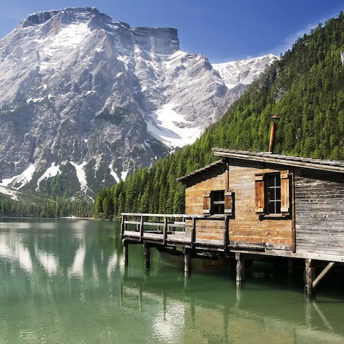
The journey across the Alta Via 1 is defined by a series of spectacular sights, beginning at the iconic Lago di Braies, situated at 1,496 m4,908 ft. This emerald lake provides a dramatic starting point before the trail climbs into the high limestone plateaus.
One of the most unique features of the route is the opportunity to walk through history near Passo Falzarego. Here, hikers can explore the Galleria Lagazuoi, a massive tunnel system from the Great War carved directly into the mountain. Emerging at the summit of Lagazuoi at 2,752 m9,029 ft reveals one of the most expansive views in the entire range, where the sunset paints the surrounding peaks in brilliant shades of red and purple. As the trail moves south, you will walk beneath the towering vertical walls of the **Civetta and Pelmo massifs before descending into the wild, isolated valleys of the Dolomiti Bellunesi.
The Reality of the Alta Via 1
While the highlights are glamorous, the AV1 is a serious endeavor. Spanning 120 km74.6 mi, it stays almost entirely at high altitude.
Is This Trek For You? (The Fitness Check)
The AV1 is famous because it is the "easiest" of the high routes. It requires absolutely no mountaineering or via ferrata gear (unless you choose optional variants). However, "non-technical" does not mean "easy."
- The Daily Grind: You will walk 6 to 8 hours a day with an 8-10 kg17-22 lb backpack.
- The Vertical Toll: You will climb and descend an average of 800 m2,624 ft to 1,000 m3,280 ft every single day. Your cardiovascular system and your knees will be tested far more than your climbing skills.
The North vs. South Divide
The AV1 is a tale of two mountain ranges. The psychological and physical shift happens right in the middle at Passo Staulanza.
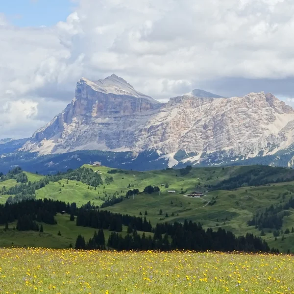
- The Northern Half (Days 1-4): This is the manicured side of the Dolomites. The trails through the Fanes plateau and around Cortina are wide, heavily trafficked, and relatively smooth. The huts (like Lagazuoi and Fanes) are massive, offering hot showers, private rooms, and espresso machines.
- The Southern Half (Days 5-9): Entering the Dolomiti Bellunesi National Park, civilization disappears. The trails become narrow, rugged, and choked with loose scree. The crowds vanish. The huts are primitive, isolated, and supply basic, hearty mountain fuel.
Crucial Logistics & The "Booking Bloodbath"
You cannot simply show up to hike the Alta Via 1. It requires military-level planning.
- The Booking Window: The mountain huts (Rifugios) open their booking systems between December and February for the following summer. By March, the peak months (July and August) are entirely sold out. You must plan this trek 6 to 8 months in advance.
- Wild Camping is Illegal: Do not bring a tent. Wild camping is strictly forbidden along the entire route, and National Park rangers actively patrol and fine hikers in the southern sections.
- The Lago di Braies Trap (Day 1): During the summer season, the road to the starting point at Lago di Braies is closed to private vehicles from 09:30 to 16:00. You must book the public shuttle bus from Dobbiaco/Villabassa months in advance, or arrive before 08:30.
What Must Be in Your Pack?
You are sleeping in full-service huts, which means you do not need a tent, sleeping pad, or cooking stove. Your base weight should not exceed 8 kg17.6 lbs.
- The Mandatory Sleeping Liner: All Rifugios provide heavy wool blankets or duvets, but for hygiene reasons, you are legally required by the Alpine Club to bring a lightweight silk or cotton sleeping bag liner. You will be denied a bed without one.
- Cash is King: While northern huts take Apple Pay, the remote southern huts rely on spotty radio-internet connections. Storms knock out the card machines frequently. Carry at least €300 in physical cash to cover your lunches, beers, and emergency taxi bail-outs.
- Extreme Weather Layers: The route peaks at Rifugio Lagazuoi (2,752 m9,029 ft). Even in the first week of August, this summit regularly experiences freezing temperatures, gale-force winds, and snow flurries. A premium hard-shell rain jacket, a fleece mid-layer, gloves, and a beanie are non-negotiable.
- Trekking Poles: These are not optional. The relentless, steep descents on loose limestone scree will destroy your knees without the weight distribution of poles.
Explore More Treks
Alpe di Siusi
Experience Europe's largest high-altitude alpine meadow. The Panorama Traverse offers a gentle yet spectacular circuit through emerald pastures, framed by the anvil-shaped Sciliar and the towering spires of the Sassolungo. Perfect for photographers and families alike.
Cinque Torri Loop & WWI Open Air Museum
Explore one of the most famous rock formations in the Dolomites. This guide covers the WWI trenches, the loop around the five towers, and the climb to the historic Rifugio Nuvolau.
Lago di Braies
Visit the most famous lake in the Italian Dolomites. This guide covers the essential shoreline loop, the easy hike to Malga Foresta, and critical 2026 parking and shuttle regulations.
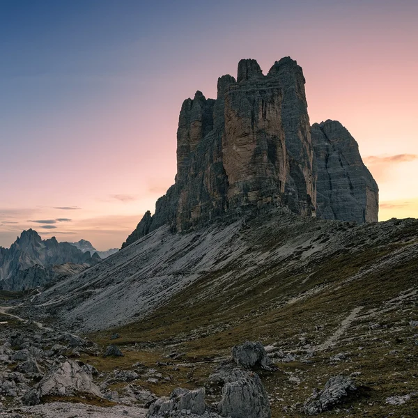
Tre Cime di Lavaredo Loop
Circle the most iconic monoliths in the Alps. This essential day hike brings you face-to-face with the dramatic north faces of the Three Peaks, traversing high-altitude scree fields and historic WWI tunnels in the heart of the Sesto Dolomites.
From our partner · 400+ Verified Traveler Reviews
"This trek is magnificent. The itinerary is perfect, and our guide was extraordinary - knowledgeable, attentive, and genuinely passionate about the Dolomites."
"Well-marked trails that avoid the crowded tourist spots, with real elevation changes that keep it interesting. The mountain hut stays were a highlight - the Italian food at every rifugio was outstanding."
"Our guide was super professional. The transportation was seamless, and the family-run hotel was very comfortable - a friendly and safe setting. I would do it again in a minute."
"Excellent itinerary, excellent guide. Every detail was handled perfectly and the route choices were spot on. Would do it again without hesitation."
"A spectacular trek through an exceptional mountain range. The route avoids the most crowded areas and the views are relentless. Be warned - the elevation changes are more demanding than you expect."
"A genuinely engaging trek that keeps you motivated day after day. The variety of landscapes - from green valleys to high rocky passes - is remarkable. Well organized from start to finish."
"I rate this trip 10 out of 10. The accommodation quality exceeded my expectations, and the staff were incredibly attentive - even accommodating my food allergies without any fuss."
"An extraordinary itinerary that lets you discover the Dolomites without overexerting yourself. The route is well-balanced with no technical difficulties, yet you still feel immersed in the high mountains."
"A great discovery for a first group hiking trip. The guide was excellent, the group was friendly, and the autumn weather gave us clear skies over the Dolomites nearly every day."
"A wonderful week in the mountains with an excellent guide who knew every trail and every shortcut. The hut-to-hut format made the logistics effortless - just walk and enjoy."
Decades of Alpine Expertise
Our partner agency has been operating in the Alps for over 40 years. Their team of passionate mountain experts knows every trail, every rifugio, and every season intimately.
Fully Protected Trips
Your investment is safe. We work exclusively with a licensed, bonded, and insured operator. 24/7 assistance and comprehensive travel insurance are included with every booking.
Handcrafted by Locals
No generic packages. Each itinerary is designed by a small team of travel experts who hike these trails themselves. Luggage transfers, dietary needs, and every logistical detail are handled for you.
A Real Team, Not a Call Center
A dedicated team of a dozen specialists is available before, during, and after your trip. You speak directly to the people who designed your route and know the terrain.